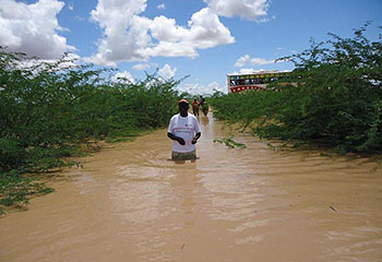
Heavy rains in Kenya cause flash floods and road cutoffs in major tourist areas
The Rift Valley game parks and the routes to Masai Mara are among the most affected
 30/04/2013.
Torrential downpours that have been falling in Kenya since the beginning of the long rains season in March have left an outcome of 56 people dead and more than 85,000 displaced, according to informations provided by the Red Cross.
Concerning the major tourist areas, the Western region, the Rift Valley, the Nairobi area and the coastal towns of Kilifi and Malindi have been severely affected. In all these regions the heavy flooding has resulted in landslides and many bridges have been washed away, making roads impassable.
Other regions less favoured by tourists, like the Northeast and the Tana delta, have also suffered great damage.
Waterlogged parks
Water has overflowed at Nairobi National Park, where several roads are closed to traffic and others are only accessible to 4x4 vehicles, Gareth Jones reports at The Star.
The largest floods in tourist areas have occured in the Rift Valley, where lakes have spilled over adjacent farmlands and riverine roads.
In the Nairobi-Nakuru highway, near Naivasha town, a bridge was washed away, The Star reports. The level of lake Nakuru has risen to near the main gate, flooding the access road to Baboon Cliff and other tracks. The park authorities have opened alternative routes to ensure that all park attractions are accessible by road.
Lake Bogoria has also overflowed swallowing up the access road to the southern shore, where some of the campsites and picnic sites are located. The swelling of the lake has also concealed the landmark thermal geysers, Steve Kinuthia reports at The Star.
The roads leading to Masai Mara have also been affected. Huge cracks have appeared on the road from Mai Mahiu to Narok, Macharia Wamugo reports at The Star. Heading on to the reserve from Narok, the road to Ololamutiek has been made impassable after several bridges collapsed. The road to Sekenani is the only one that remains open, but both this route and the roads network within the reserve are hardly passable.
Spokesmen on behalf of Kenyan authorities have assured that repair works will begin immediately to warrant road communications throughout. A statement from Kenya Meteorological Department forecasts that heavy rains will proceed through much of May.
|


